Whittier's New Disaster Plan Shows Who Faces the Greatest Risk
From a $7 billion earthquake threat to year-round wildfire risk, the new hazard plan spells out what a major disaster could cost.

The City of Whittier adopted its first disaster risk update since 2016 this week, a 390-page plan that spells out what a major earthquake, wildfire, or other natural disaster could cost the city, and which residents would be hit hardest.
The City Council voted June 23 to approve the 2025 City of Whittier Hazard Mitigation Plan. To remain eligible for FEMA hazard mitigation grants, cities must update these plans every five years.
More than a planning document, the report is a map of the city's weak points. From hillside neighborhoods vulnerable to wildfire to aging underground infrastructure and older housing more susceptible to earthquake damage.
Here's what it says.
The earthquake threat covers the entire city
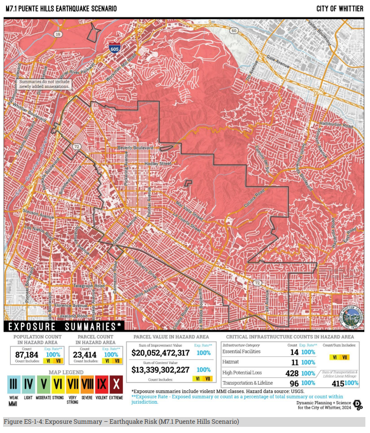
The plan's most striking finding: if the Puente Hills fault ruptured in a magnitude 7.1 earthquake, every resident, every property, and every city facility would be in the shaking zone. There's no part of Whittier that escapes it.
The plan estimates roughly $7.1 billion in damage from that scenario. Homes would take the biggest hit at about $4.2 billion. Businesses another $1.9 billion.
A fault farther away, the Elsinore fault, could produce a larger magnitude 7.3 quake, but it would shake Whittier much less. That scenario puts estimated losses at $618 million. Serious, but less than a tenth of the Puente Hills number.
The 1987 Whittier Narrows earthquake, a 5.9 centered in Rosemead, caused up to $358 million in damage and hit Whittier's Uptown especially hard, severely damaging at least 200 older homes and 30 businesses. It injured about 200 people across the region and killed eight. It struck at 7:42 on a Sunday morning, when most buildings were empty. The plan notes that timing kept casualties down. A 7.1 wouldn't offer the same luck.
Liquefaction: the earthquake risk most people don't think about
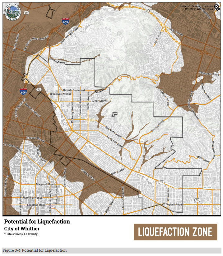
When people picture earthquake damage, they picture fault lines. But the plan flags a different threat that affects far more of the city: liquefaction.
When certain soils get saturated with water and then shaken, they stop behaving like solid ground. Foundations sink. Buildings shift. About 10,600 Whittier residents live in areas where this could happen, with roughly $4 billion in property at risk.
By comparison, the narrow zones where the ground could actually split open along a fault line affect only about 440 people and 29 parcels. The fault gets the headlines, but unstable soil is the more common risk.
Wildfire starts in the hills. Its impacts don't stay there.
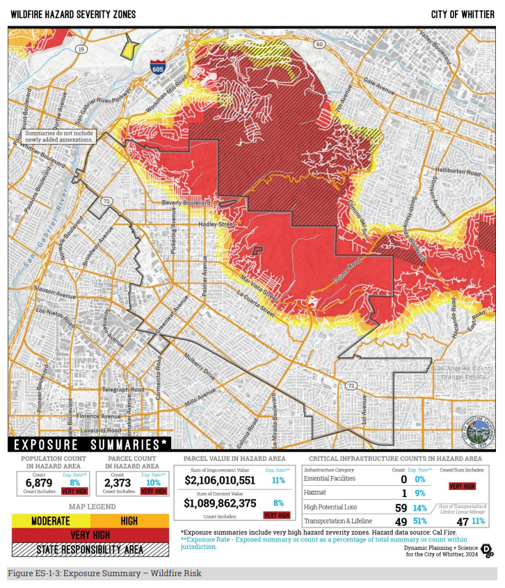
Almost 14,000 residents, about 16% of Whittier, live in areas the state has designated as moderate, high, or very high fire risk. That's mostly the Puente Hills: Turnbull Canyon, Peppergrass Trail, the Hacienda Hills area. About 6,900 of those residents are in the highest-risk category.
More than $5.6 billion in property sits in fire hazard zones, about 17% of the city's total property value.
Fire season in Los Angeles County is now effectively year-round. The brush in the Puente Hills is at least 50 years old in many areas, thick, dry, and on steep slopes where fires move fast. When Santa Ana winds kick in, conditions can go from bad to catastrophic quickly.
About half the roads and utility lines the plan accounts for run through fire hazard areas. In a fast-moving hillside fire, that's an evacuation problem, not just a property one.
And even if you live nowhere near the hills, you're not off the hook. A major Puente Hills fire would push smoke, service disruptions, and road closures across the whole city.
Climate change is making all of it worse
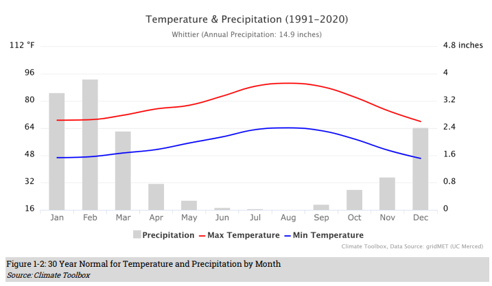
The plan treats climate change as a major hazard on its own, not just a backdrop. For Whittier, that means more days above 90 degrees, a permanent fire season, worse and longer droughts, and more intense rainstorms that actually do less to replenish the water supply.
The plan says climate impacts won't fall evenly across the city. Residents with fewer financial resources, health challenges, or mobility limitations are expected to face greater risks.
Who's most at risk
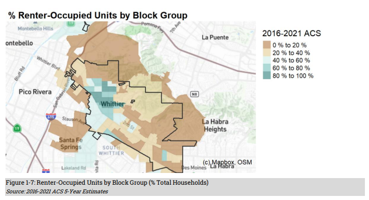
More than half of Whittier households rent, higher than the county average. Renters have less control over whether a building gets retrofitted, whether there's backup power, or whether the property around them is properly maintained for fire safety.
Nearly 8,000 residents have a disability. About one in 17 households has no car, which matters a lot if an evacuation order comes. Nearly a third of households include someone 65 or older, with the highest concentrations of seniors living alone in Uptown and South Whittier. Older residents face layered risks: they're more vulnerable to heat and smoke, often on fixed incomes, and may need more help getting out.
More than a third of households are Spanish-speaking. The plan flags this as a direct concern for whether emergency information actually reaches people in time.
One thing worth noting about the process
The city collected resident input partly through an online survey that ran from October 2023 to January 2026. It drew 84 responses. Of those respondents, 85% owned their home, in a city where 57% of households rent.
Data from other outreach efforts, including in-person events, are not reported in the plan, so the online survey is the only public input with a documented response count.
What the city says it will do
The plan lists 42 actions, 20 new since 2016. The big ones: replacing aging water and sewer pipes, managing brush in fire zones, more public education, and pursuing outside grant funding for retrofits and infrastructure upgrades.
One specific project to watch: Whittier is pursuing a shared water line with the City of Santa Fe Springs that would deliver backup water supply if local pipes fail after a major quake.
The plan also echoes concerns the city has raised elsewhere about aging underground infrastructure. Whittier's sewer system includes about 190 miles of pipe, much of it installed in the 1950s, with more than $100 million in identified repair needs.
One honest caveat the plan includes: the city doesn't control private utilities, the water district, state highways, or hospitals. Anything on that list is outside Whittier's hands.
Adoption of the plan doesn't mean those projects are funded. Many of the 42 mitigation actions depend on future grants, partnerships, or capital improvement budgets. But with the plan now adopted, the city remains eligible to compete for federal funding to help pay for them.
The 2025 City of Whittier Hazard Mitigation Plan and supporting documents were included in the June 23 City Council agenda packet.